Climbing Island Peak 6,189m,Climbing Island Peak 6,189m,

Island Peak Climbing 6,165m,

  • Duration20 Days
  • DestinationNepal
  • Difficulty Challenging
  • Max Altitude 6,165m
  • Activity Trek and Climbing
  • Group Size min- 2
  • Accommodation Comfortable hotel and lodge
  • Meals Three times on Trek
  • Transportation Domestic flight and private vehicle
  • Starts Lukla
  • Ends KTM
  • Best Season Spring (March-May) or Autumn (Mid-September - October)
Overview
Trip Highlights
  • The Island Peak Summit at 6165 meters and the most astonishing views from the peak
  • Testing yourself for high mountains expeditions
  • Side trip to Gokyo Ri 5,380m, - Chola pass 5,420m,- EBC 5,360m,- Kalapatthar 5,545m,- Kongmala pass 5,535m,
  • Amazing views of Mt. Everest, Lhotse, Cho- Oyu, Makalu, Ngozumba, Gyachungkhang, Nuptse, Changtse, Pumori, Ama Dablam, Chumbu, Thamserku, Kangtega, Cholatse, Taboche & Lobuche
  • The highly respected and biggest Tyangboche Monastery in the Everest Region
  • Magnificent vistas of the biggest Ngozumba glacier, the longest Khumbu glacier, Khumbu Icefalls, monuments, stupas and , prayer flags
  • Traditional Sherpa settlements, their unique and rich Tibetan Buddhism culture, tradition, custom, lifestyle, and hospitality
  • Unique flora and wildlife on the trail inside the Sagarmatha National Park

Island Peak Climbing

Island Peak is one of very famous trekking climbing Peak in Khumbu Region. It lies away up the Chhukung Valley and is locally known as Imja Tse, This Peak is dwarfed on both sides by the stupendous Mt. Lhotse/ Nuptse South wall to the North and Mt. Bharuntse to the South. Island peak climbing is a popular destination for climbers who are dreaming of high mountain expeditions. The legendary climbers Sir Edmund Hillary and Tenzing Norgay Sherpa also trained themselves at this peak before their successful summit at Everest in 1953 and the route they discovered is the same one that is used today. In fact, Island Peak is still a popular training peak for clients attempting high Mountains expeditions because a lot of the skills required at Island Peak for crossing crevasses with ladders, using jumars on a fixed line, or climber must be prepared perfectly with every climbing equipment and technique.

Touren Nepal Treks makes a perfect itinerary for Island peak climbing including Trek from Gokyo Lake. Our main purpose is safety, security, and a successful mission in the Himalayas. The gradual ascent up the Gokyo Valley, Gokyo Ri 5,380m excursion, Chola Pass 5,420m, Khumbu Valley, Kalapatthar excursion 5,545 m, Everest basecamp hiking 5,360 m, and possibly Kongma La Pass 5,535m, allows for excellent acclimatization and that enhanced easier on Island Peak Expedition.

Before reaching Island Peak, we want to bring you from Lukla up to the round trek for learning and practicing alpine skills in the Himalayas. During the trek, you will learn and use many skills in safe travel in the mountains at high altitudes including glacier travel, scrambling and moving on mixed snow, adjustment at high passes and temperature, moraine/ ice terrain walking stamina, and sufficient acclimatization.

The approach route follows the Chukkung Valley to Island Peak Base Camp. You arrive at base camp by noon time and after lunch, your Climbing guide will train you there about climbing and using the proper method of climbing equipment. The summit route includes circuitous rocky paths and scrambles to the snow line, followed by a section of terrain and crossing glacier crevasses using a climbing rope, Jumar, ascender, and descender, negotiating some ladders across crevasses, and then a 300-meter headwall to the summit ridge. The headwall is fixed with a rope to clip onto, and this extends along an exposed summit ridge about 300 meters long which is narrow and precipitous but not steep. The top itself is quite a small place for maybe four or five people to stand but the views are gorgeous.

Itinerary

Arrival at Kathmandu international airport, we greet you with flower garland and transfer to the Hotel and evening trip briefing at your hotel

Drive a couple of hours very early in the morning to Ramechap airport by car and take a short flight to Lukla (2800m). Your trekking supporting staff are waiting for you in Lukla, they will come to collect you at the airport counter and take you to the lodge for breakfast by the same time we make an introduction then start slowly trekking via Chaurikharkha, Kyangzoma, Ghat to Phakding village (2640m) for overnight.

We commence our trek to Namche Bazaar through the Dudh Koshi River bank. Today we will cross so many suspension bridges over the Dudh Koshi River. The zigzag trail leads us through Banker, Monjo to Jorsalle. Jorsalle is the check post of Sagarmatha national park and trekking permits. Thamserku, Kusumgaru, and Kwongde Mountain are visible all day long today. The Khumbila Peak is just standing over the Namche bazaar. We follow the uphill trail from the riverbed of this V-shaped valley where the river forks Dudh Koshi and Bhote Koshi are meeting each other. Now we begin steep ascending to Namche Bazar. We make a quick stoppage just over the shoulder of steep up after one and half hours of walking from there you will have the 1st excellent view of Everest (8848m) and Lhotse (8516m.)Then it takes approximately 45 minutes to arrive at Namche Bazaar. Bellow the Namche Bazaar there is also a check post for checking your permits.

Acclimatization day is considered an ideal day for altitude acclimatization in this place, after breakfast just get higher around the museum. There is very nice viewpoint including the statue of Tenzing Norgay Sherpa and rounding mountain views such as Mt. Everest, Lhotse, Tawache, Nuptse, Amadablam, Thamserku, Kusumkangaru, Kwonge Peak, and Thame Peak. It would be the best morning ever in your travel time then follow the steep climb up to the world’s highest airstrip airport “Syangboche”. Turn right across the Everest View hotel to Khumjung village for a day excursion, visit the monastery which is still preserving a yeti’s head then get back down to Namche by aside the Khumjung school or if you want to go to Khunde village you can continue climbing and take a direct way to Namche bazaar from Khunde.

It is an easy flat trail until Sanasa through birch, pines, and fir trees with fine views of mountains. From Sanasa it climbs for one and a half hours up to Mongla Danda then descends to Phortse Tanga. A well-known and typical ancient Sherpa village phortse is nicely visible along the way. There is a dense alpine forest of fir, rhododendron, birch, alpine bamboo, and pines between Phortse Tanga to Dole. The trail is scenic and mostly gradual uphill through the alpine forest.

scale up the way slowly to the ridge from there you will see a giant big mountain wall standing in the forehead is Mt.Cho Oyu 8201m. The trail is not steady up however it is gently ascending through Luza. Today you will see a lot of yak pasture fields. In the former time, people from Khumjung, Kunde, and Phortse used to bring their animals into this valley thus still the land ownership is highly belonged to those people from the same village. Finally, we will arrive by clearing one hill lap to another into a Fish shaped valley in Machhermo village.

We have a short walk today. We will arrive at Gokyo by lunchtime. After lunch we climb up the glacier edge for exploration. On the way, a little settlement called Fanga village appears there was a big avalanche of devastation in 1996. The trail crosses the rocky narrow hill near the glacier and turns around the valley towards the lake. There are many beautiful lakes in Gokyo Valley, behind the lakes there is a big glacier laying, which is spreading from the bottom of Mt.Cho –oyu. After walking slowly around the rocky corner you will reach the third lake where you are staying for the overnight at 4750m.

: Explore Gokyo Ri early in the morning which may take three hours up and down. Gokyo Ri is one of the best viewpoints that offers a panoramic view of Mt. Everest 8,848m, Lhotse 8,516m, Lhotse Shar 8,383m, Makalu 8,481m and Cho Oyu 8,201m and several other mountains such as Mt. Pumori (7161m), Ngozumba, Gyazungkhang, Tawatse, Cholatse, Mt. Changste (7550m), Mt. Lingterin (6679m), Mt. Amadablam (6856m), Bharuntse, Thamserku (6723m), Kantega( 6685m), etc. And a huge Ngozumba glacier and a fine view of local Lakes. Descend to the lodge for breakfast then start the trek to Thangnak by crossing a huge Ngozumba glacier. Overnight at Thangnak 4700m.

The trail goes into the deep mountain valley by following a small river stream. It crosses several hillocks, glacier moraine to the Chola Phedi. Ascending over the rocky part takes almost a couple of hours. You frequently meet other trekkers who are coming from EBC trekking on this cliff. There was a big problem for ascending and descending during a heavy snowing time but it is quite easier now by fixing fixed steel strings around scary and riskier places. You must carry a picnic packet for the day while it is an important day over 5,420m, Chola pass. After the pass trail crosses a big part of the ice field and gradual descent to the Small settlement of Zhongla.

Start your trekking just after your breakfast. The views are very honorable such as Mt. Chola tse, Tawatse Peak, Lobuche Peak, Nuptse Peak Amadablam Peak, Chola Lake, and a wide alpine pasture field. The Khumbu legendary trail meets at the memorial site that comes across Pheriche village downtown. Pheriche is a famous Highlander village with a Rescue center and comfortable lodges. Follow the trail that gradually climbs toward EBC. Within some hours of ascending you will arrive in Lobuche (4900m) and make your lunch here. It takes almost 3 hours of a demanding walk through Gyazungkhang glacier, the rocky gregarious moraine trail, and the giant longe bed of Khumbu glacier to the right side. Mt. Pumori, Nuptse, Gyzungkhang, Ngozumba are towering Mountains. And a wide and big glacier and Khumbu Icefall will be enormously visible over the tour. Overnight at Crowed and the ultimate place Gorakshep.

Start climbing up to the Kalapatthar very early in the morning with a flashlight for nice sunrise views. It takes approximately one and a half-hour’ time. You can see enormous spellbound views from Kalapathhar, Mt. Everest is very nicely visible from Kalapatthar. Mt. Lhotse, Nuptse, Pumori, Lingtren, Khumbutse, a wide range of Everest basecamp, Khumbu icefall, long range of giant Khumbu glacier, Mt. Makalu, Bharuntse, Amadablam, Tauche, Thamserku and complete Himalayan glacier covering landscape are visible. Pumori base camp lies just below Kalapatthar with gleaming Glacier Lake. Descend to the hotel for breakfast and prepare your baggage for the porter. Porters will descend to Lobuche earlier while you will make a side trip to Everest basecamp in the noon with some picnic package. Get back to Gorakshep for some drink or soup then descend directly to Lobuche for overnight.

Today is another important day for crossing Kong Ma la 5,535m, pass. The trail is quite tough till the pass then it is easy descending until you reach Chhukung.

Take a Rest day or Preparation og climbing the peak, check and manage every climbing gears. You can also take on rent some necessary gears at Chhukung. Every Hotel they provide all kinds of climbing gears in Chhukung.

Your Island Peak expedition team starts with a completed outfitter preparation such as tents, food, a cook, a helper, and a climbing guide. You will arrive by lunch at base camp, make some rest then the whole noon time is for climbing training by your climbing guide.

Normally climbing start at 2:00 Am from base camp, or starts according to your own conditions. It takes approximately 12 hours of walking all the way up to Island Peak summit and down to base camp. If you have time then better to descend to Chhukung overnight will be more comfortable rather sleeping in a tent in base camp.

A spare contingency day should our summit attempt be in any way delayed due to bad weather or the need to rest for another day. If not needed it will be added on as an extra free day in Kathmandu

Easy walk down via passing the legendary villages Dingboche, Pangboche to the highly respected holy Tyangboche Monastery for overnight

 Return back down to Namche bazaar and descend to Monjo for overnight at a comfortable hotel.

Easy descending to Lukla and farewell dinner together with your trekking crews. Give thanks for the hard work of this mission come true with some presents or TIPS.

Take a morning flight to Manthali and drive back to KTM, free at noon time. And farewell dinner at your trip organizer.

Route Map
Island Peak Climbing 6,165m, map
Cost Details

The cost of this trek depends on accommodation in the city, group size, transportation usage, and level of services. We provide special discounts for larger groups, relevant travel companies, partners or agents, and non-profit organizations. Just let us know your quaries then we provie you the best of your price.

And in addition, we charge U.S. $ 835 per person for Island Peak Climbing

The charge includes: Base Camp Services, Base camp to Island Peak Summit, a climbing Guide, and Climbing Permit, climbing Insurance for Nepali Team, food, and tents, or an outfitter setting during Island Peak climbing at base camp.

What's included
  • Airport Pick up & drop by private vehicle
  • KTM- Manthali- KTM private vehicle
  • Flight from Ramechhap- Lukla- Ramechhap
  • Flight cost for your guide
  • 3 Night Hotel in Kathmandu on B/B planning
  • Island Peak Climbing permit
  • Sagarmatha National Park entry Permit
  • (TIMS) Trekkers information Management System Fees (Permit)
  • Khumbu Pasang Lhamu Rural Municipality entry Fees (Permit)
  • Accommodation during the trek and tents and food at Island Peak base camp
  • Three meals per day (Breakfast, Lunch & Dinner) during the Trek
  • An Experienced trek and climbing guide including necessary porters and staff
  • Transportation, wages, meals, accommodation, allowance, equipment, and insurance for all the staff including the climbing guide
  • Trekking camping equipment (tent, mattress, dining tent, kitchen tent, toilet tent, all kitchen gear/utensils if necessary during the Climbing period
  • Fixed rope for climbing
  • Garbage deposit fees
  • All the official paperwork and all applicable government taxes
  • Farewell dinner
  • First aid Kid
What's not included
  • Lunch and dinner in the City
  • Your travel insurance
  • Your personal expenses
  • Your medical expenses
  • All kinds of beverage drink and your communication cost
  • Helicopter price in case you need quick evacuations
  • Tips for your staff
  • Trip cancellation cost
  • Your health insurance, loss or damages of belonging
  • Hotel in case more than 3 nights in the city
  • Sightseeing and tours cost around the world heritage site
Useful Info

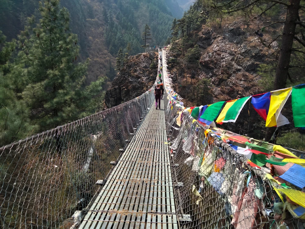
Notice for domestic flights to and from Lukla:

The Tribhuwan International Airport and the domestic Airport are partially the same in Kathmandu. So it used to be a heavy air trafficking during international flights. That is affecting tremendously for the smooth flight operation to Lukla which is mostly departing early in the morning. Most of the tourists come to Nepal for Everest region trekking and the main gateway to enter into this legendary region is by flight to Lukla. The airport in Lukla is only suitable for small aircraft so there would be uncountable flights in a day. Thus, aviation had decided to operate regular flights not from Kathmandu but from the nearest airport of Kathmandu during the main tourist season. At the moment, the nearest airport is in Manthali Ramechhap, which is approximately 4 hours drive away.

The flights are effective from the beginning of October to the End of November in autumn and March to mid-May in spring.

Most tourists get to drive in the middle of the night from Kathmandu to Manthali for the next day’s morning flight. But we recommend moving a day earlier from Kathmandu to nearby Manthali. That will provide the perfect views of the countryside of Nepal and also would not make the rush and uncomfortable drive.
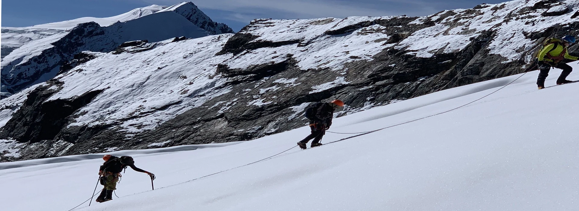
Altitude sickness:

Altitude sickness (acute mountain sickness) is difficulty of sleeping, dizziness, headache, fatigue, loss of appetite, rapid pulse, nausea, vomiting, etc. It affects mountain climbers, hikers, and skiers because of lower air pressure and lower oxygen levels. It occurs as the result of failure to adapt at a higher altitude. It happens most often in the brains or the longs after the fluid begins to leak from the blood vessels.

When the fluid collects in the brain, you initially get headaches, loss of appetite, nausea, tiredness, want to lie down and feel powerless, physically moving is unwilling, and a decrease of consciousness, and the problem with balance coordination is called high–altitude cerebral edema (HACE). If the fluid is collected in the lungs, you become breathless and dry, and it makes regular irritative cough, sometimes coughing up blood too, discoloration of the skin, and chest tightness is called high altitude pulmonary edema (HAPE).

Prevention:

To prevent acute mountain sickness; we have to follow fundamental gravity habits such as patience, consistency, and discipline in the mountain. The mountains have their own rule and regulations. We cannot turn them into our nature except by following and respecting them. Cloth on properly according to the altitude, avoid rapid altitude gain, drink enough water or fluid, take enough acclimatization time to adjust the body at a higher altitude, avoid alcoholic items, control smoking, eat regular meals, get higher & sleep at lower altitudes. Avoid high altitudes if you have heart and lung disease. If the symptoms occur then stop climbing mountains and descend to a lower altitude. In case the person is seriously sick, or cannot bring him/her to a lower altitude by walking and carrying then she/he should be rescued by quick Helicopter evacuation.

Clothing Equipment:

  • Lightweight walking boots, a pair of track shoes, and slippers to wear in the evening or when the boot is wet.
  • Warm jacket (Fibers fill or down should be adequate.)
  • A Rainproof jacket with a hood or poncho.
  • Warm clothes or fleece jackets.
  • Thin and thick trousers.
  • Warm trousers are useful higher up in the mountains in the morning and at night. (Windproof/ waterproof trousers are necessary during treks going above 3000mtr)
  • Thermal underwear (These are excellent for sleeping at night)
  • A pair of loose-fitting long shorts and 1 lightweight long-sleeved –shirt are particularly suitable for avoiding sunburn.
  • A woolen or warm hat to wear in the morning and at night. Sunhat and ensure it has a wide brim to cover the face and neck.
  • A pair of gloves (warm and normal ones)
  • 2 pairs of thin and 2 pairs of thick warm socks.
  • Underwear, buff, and hankies as you need.

Accessories:

Duffle bag or kit bag to carry your gear while trekking, sleeping bag. Small rucksack to carry personal requirements for the day e.g. toilet paper, towel, soap, etc. Water bottle. Snow glasses and sunglasses, 2-4 large plastic bags to separate clean clothes from dirty ones. Headlamp with spare batteries, sun cream, personal medicine, lip guard, toothbrush, towel, Reading materials, game items (optional), notebook, rubber band, pen and pencil, a diary, a pocket knife, trekking map, passport, and copies.

Drinking Water:

Travelers should be very aware of drinking water in Nepal. They are not completely adapted to digest direct normal spring water due to bacteria. So, we recommend you drink mineral water or boiled water. Also, you can use some purifier tablets such as chlorine tablets for purifying water on the trekking. We strongly recommend mineral water in the city area and purified or boiled water in the trekking.

Accommodation:

We provide accommodation according to your demand and accessibility either normal standards or comfortable luxury hotels in the City. We provide very neat, clean, and comfortable hotels, lodges, friendly homestays, or locally what is available for the most suitable. And fully outfitter camping equipment such as sleeping tents, dining tent, toilet tent and kitchen tent and own cooking team at Island Peak climbing basecamp. 

Similar Packages